XC Route Comparison: Alex vs Malcolm
Two pilots launched together from Rivas with the same goal: fly to Dominical and back. They flew identically for the first hour. Then cloud changed everything.
🔵 Alex Montero
🟠 Malcolm
The Route
The Rivas↔Dominical corridor runs roughly NW–SE over mountainous terrain. Rivas launch sits at 1,720m. The route crosses a mountain ridge (terrain 1,000–1,200m) and the Tinamaste gap (650–850m) before reaching the Dominical coast. A pilot needs 1,200m+ to safely clear the ridge in either direction.
Full Flight — Altitude Profile
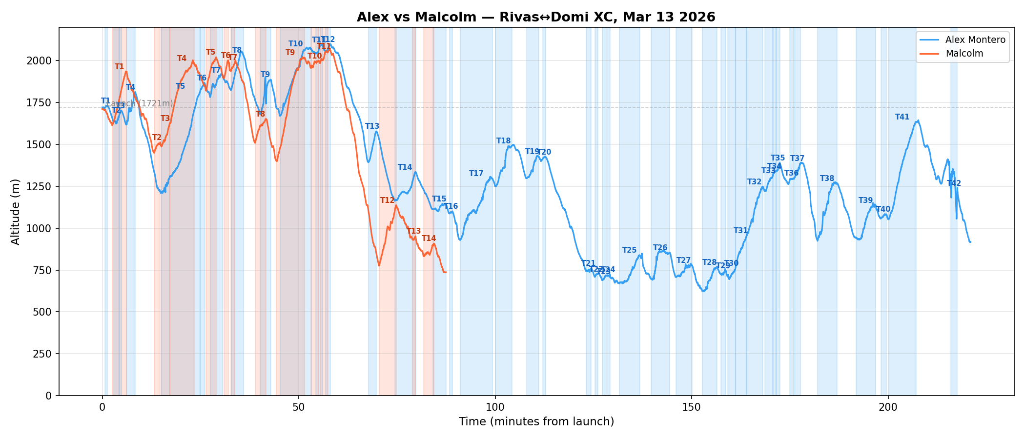
Phase 1: Together (15:52 – 16:52)
Both pilots launched within a minute of each other and flew nearly identical routes for the first hour. They thermalled the same cores, crossed the same ridgelines, and reached the same altitudes.
| At 16:50 | Alex | Malcolm |
|---|---|---|
| Position | 9.3694°N | 9.3709°N |
| Altitude | 2,078m | 2,048m |
| Gap | 30m altitude, 0.2km apart | |
Phase 2: The Divergence (16:52 – 17:03)
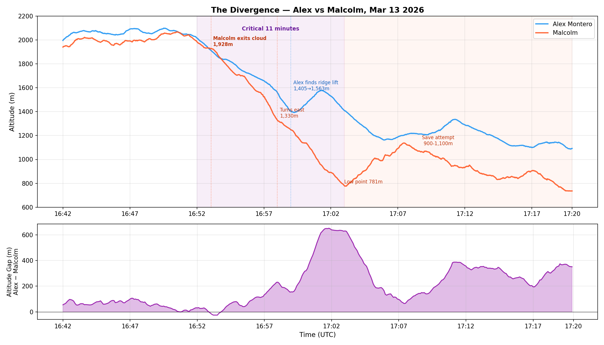
🌫️ Cloud Context
Malcolm was in cloud when the divergence began. He had zero visibility and no compass access, which fundamentally changes this analysis. He couldn't see terrain or the other pilot.
16:58
| Time | Alex | Malcolm | Gap |
|---|---|---|---|
| 16:52 | 2,016m | 1,985m | +31m |
| 16:54 | 1,837m | 1,816m | +21m |
| 16:56 | 1,714m | 1,625m | +89m |
| 16:58 | 1,561m | 1,330m | +231m |
| 17:00 | 1,454m | 1,138m | +316m |
| 17:01 | 1,563m | 1,000m | +563m |
| 17:03 | 1,411m | 781m | +630m |
Transition Numbers
| Metric (16:52–17:03) | Alex | Malcolm |
|---|---|---|
| Altitude lost | 605m | 1,204m |
| Average sink rate | -0.9 m/s | -1.8 m/s |
| Ground speed | 30 km/h | 40 km/h |
| Glide ratio | 9.1 : 1 | 6.1 : 1 |
| Seconds climbing (>0.3 m/s) | 108s | 20s |
| Track position | Over ridge (-83.76) | Valley interior (-83.72) |
Flight Map with Thermals
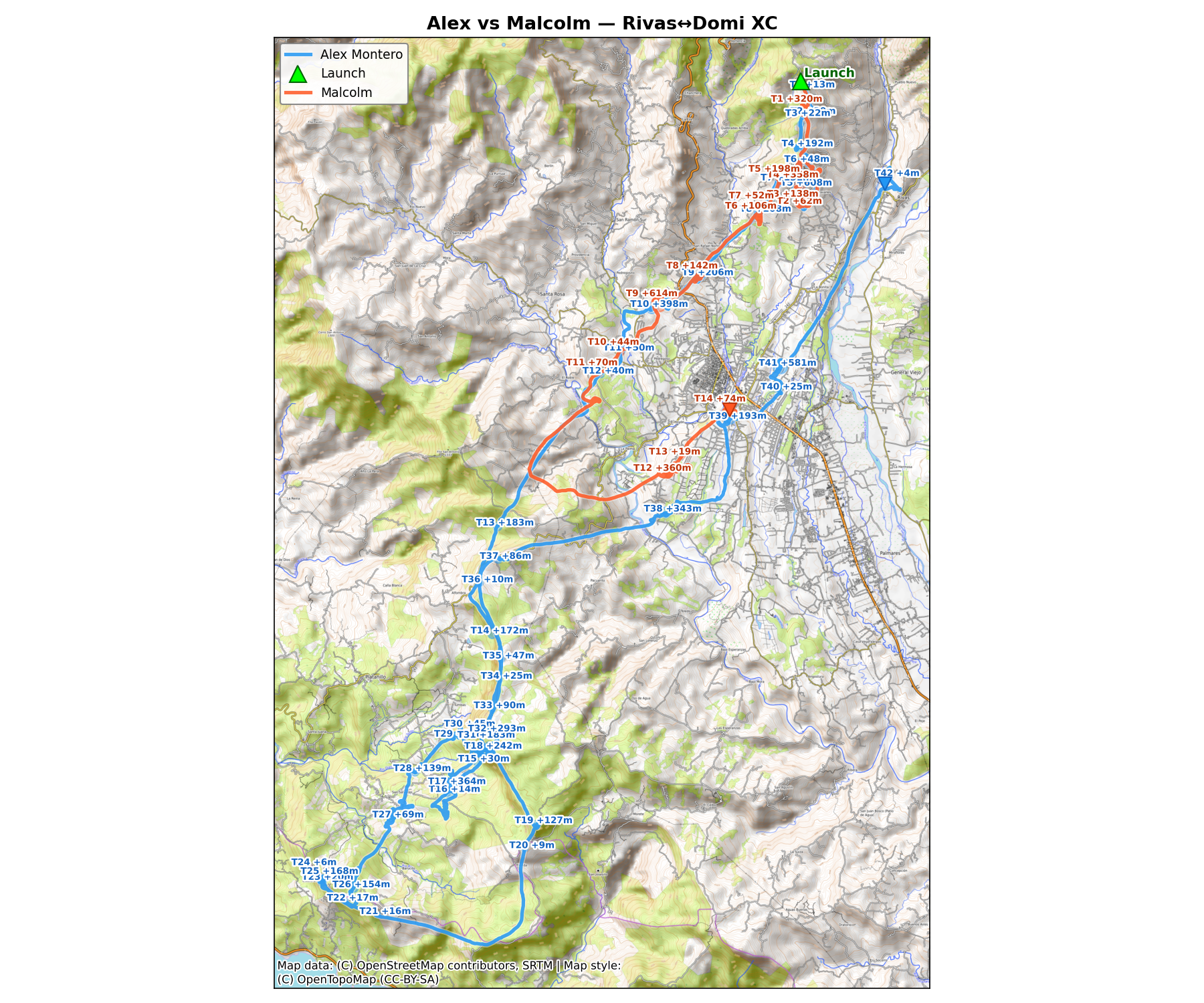
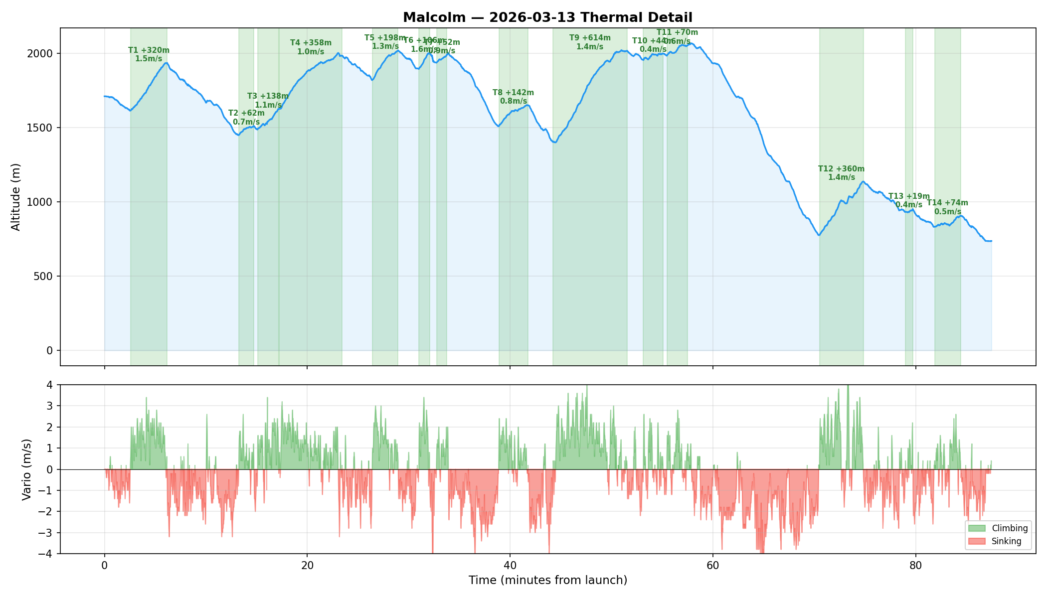
Phase 3: Malcolm's Save Attempt (17:03 – 17:20)
Malcolm found weak lift near 9.345, -83.72 and climbed from 781m to ~1,100m. The thermal topped out — valley-floor thermals over 650m terrain don't develop the same vertical depth as ridge-triggered thermals. He needed 1,400m+ to clear the ridge back to Rivas. After 17 minutes working between 900–1,100m, he landed at 737m near San Isidro.
Phase 4: Alex Completes the Return
Alex continued south to Dominical (9.22°N at 17:50), then turned north:
- Thermalling at Dominical (17:50–18:40) — reached ~1,295m
- Pushing north through the Tinamaste gap (18:41–19:06) — maintained 1,000–1,300m
- Crucial thermal at 9.37°N (19:14–19:18) — climbed 1,267→1,602m
- Gliding home (19:18–19:32) — crossed the ridge at 1,400–1,500m
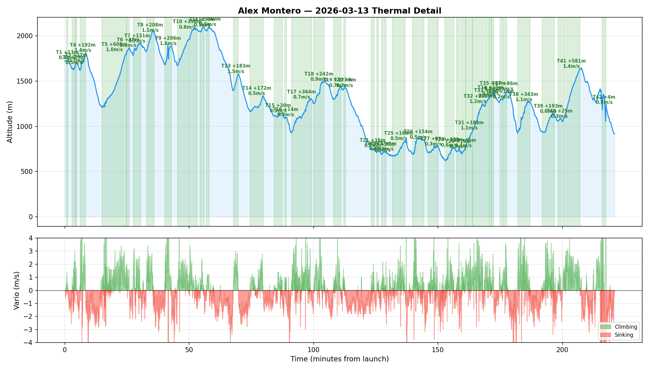
Thermal Detail — Alex
Thermal Detail — Malcolm
📊 What the Data Shows
The thermalling was equal — both pilots topped at 2,050–2,100m in the same thermal. The divergence came down to three factors:
1. Cloud forced a blind exit. Without visibility or compass, Malcolm picked a heading and committed. The heading (237° WSW) was fine for the plan. The 5-minute straight glide through -2.0 m/s sink burned 600m of altitude that could have funded a retry — but without knowing when he regained visibility, it's hard to say when he could have changed course.
2. Line selection after the cloud. Alex's track stayed over the ridge at -83.76 to -83.77. Malcolm's post-cloud line and east turn took him into the valley interior (-83.73 → -83.72), away from terrain-triggered lift. The ridge was producing pockets of lift all afternoon — Alex hit 108 seconds of climbing during the transition, Malcolm only 20.
3. Speed through the transition. Malcolm flew at 40 km/h vs Alex's 30 km/h, producing a glide ratio of 6.1:1 vs 9.1:1. When every meter of altitude matters, that speed difference is significant.
Open Questions
A few things the GPS can't answer that would sharpen this analysis:
- When did Malcolm break out of cloud? Still in cloud for all 5 minutes of the straight glide, or partway through?
- What triggered the east turn at 16:58? Visual reference? Landmark? Course correction?
- Was Malcolm on speed bar? 40 km/h vs 30 km/h — bar, or wind component?
- Any lift felt during the straight glide? Uniformly dead, or bumps not turned in?
- What was the plan on cloud exit? Specific thermal target, or just getting clear?
- During the save attempt, was heading west toward the ridge considered? Ridge at -83.76 was ~4km away.